Thierry Leblanc, NASA Jet Propulsion Laboratory, California Institute of Technology, Wrightwood, CA 92397; USA
The MOHAVE-2009 campaign took place on October 11-27, 2009 at the Jet Propulsion Laboratory (JPL) Table Mountain Facility in California (TMF, 34.4N, 117.7W). This third MOHAVE campaign involved more instruments and datasets than the two previous ones held in 2006 and 2007. The main objectives of the campaign were 1) to compare and validate the water vapor measurements (profile and total column) from several instruments including, two types of frost-point hygrometers, two types of radiosondes, four Raman lidars, two microwave radiometers, two Fourier-Transform spectrometers, and two GPS receivers; 2) to cover water vapor measurements from the ground to the mesopause without gaps; 3) to study upper tropospheric humidity variability at timescales varying from a few minutes to several days. Nine of the participating instruments are currently affiliated with NDACC.
Comparisons of the balloon-borne measurements showed small, but non negligible differences in the derivation of water vapor mixing ratio profiles by the frost-point hygrometers depending on the radiosonde pressure and temperature information used. The typical 0.5 K and 0.5 hPa differences observed between the Vaisala RS92 and Intermet-1 radiosondes measurements resulted in the mean frost-point-derived mixing ratio difference shown in Fig. 1 (from the 12 most stable CFH flights of the campaign).
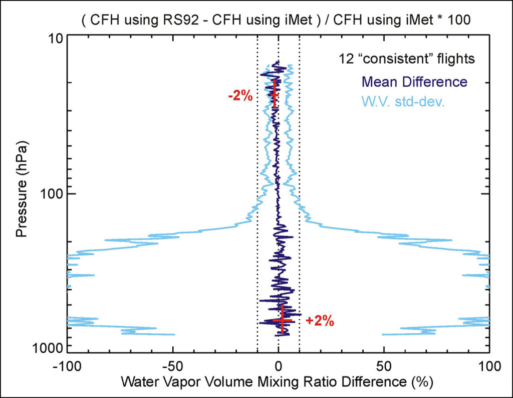
Figure 1: Effect of the differing pressure reading of the Vaisala RS92 and Intermet PTU radiosondes on the derivation of water vapor mixing ratio by the Cryogenic Frost-Point Hygrometer; The 12 most stable balloon flights of MOHAVE-2009 were used.
Over 270 hours of water vapor nighttime measurements from three of the four Raman lidars were compared to that from the radiosondes and Frost-Point hygrometer sondes. As shown in Fig. 2, excellent agreement between the JPL lidar and the CFH was found throughout the measurement range, with only a 3% (0.2 ppmv) mean wet bias for the lidar with respect to CFH in the upper troposphere and lower stratosphere (UTLS). The two other operating water vapor lidars provided satisfactory results in the lower troposphere, but suffered from contamination by fluorescence, preventing their use in the UTLS (wet bias ranging from 5 to 50% between 10 km and 15 km).
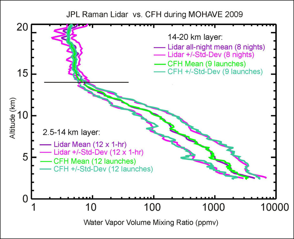
Figure 2: Campaign-mean and standard deviations of water vapor measured by lidar and CFH; a time coincidence and lidar integration time of 1 hour is used in the troposphere (below 14 km); a time coincidence of 6 hours and full-night lidar integration is used above 14 km.
Comparisons were also made in the stratosphere and mesosphere between the WVMS radiometer, Aura-MLS, and the MIAWARA-C radiometer. A typical example of the measured profiles and their uncertainties is given in Fig. 3. Between 40 and 65 km, general agreement within 10% is found between all instruments. Below 40 km, MIAWARA-C was wetter than MLS, while throughout the stratosphere WVMS was generally drier than MLS. These discrepancies are currently under investigation. The numerous results from MOHAVE-2009 have shown the critical importance of such multi-techniques comparison campaigns. On one hand, they remind us that the measurements of water vapor in the UTLS remains a contemporary challenge. On the other hand, they provide new confidence in the future simultaneous detection by lidar of long-term variability of water vapor and ozone in the UTLS.
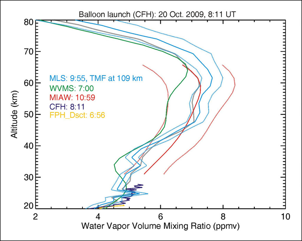
Figure 3: One example of simultaneous and co-located water vapor measurements, and their reported uncertainties during MOHAVE-2009. The microwave measurements use 6-hour integration.